|
|
|
|
Preface and General
Information
|
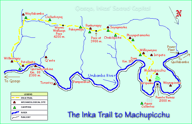
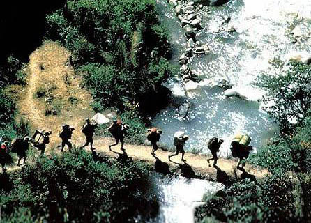
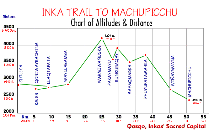
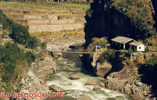
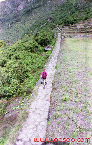
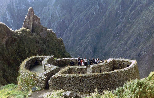
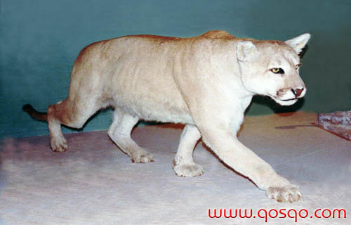
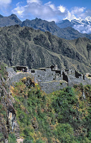
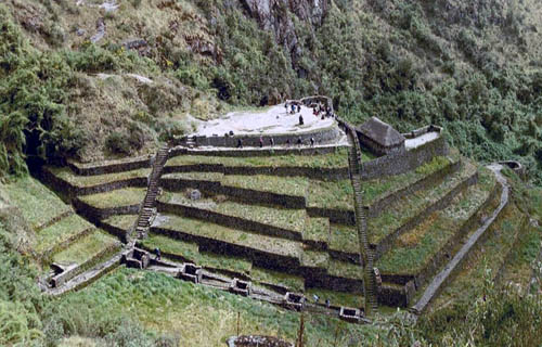
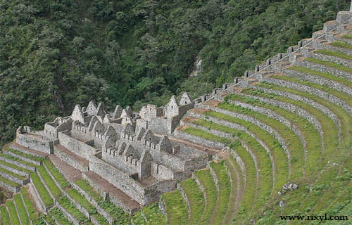
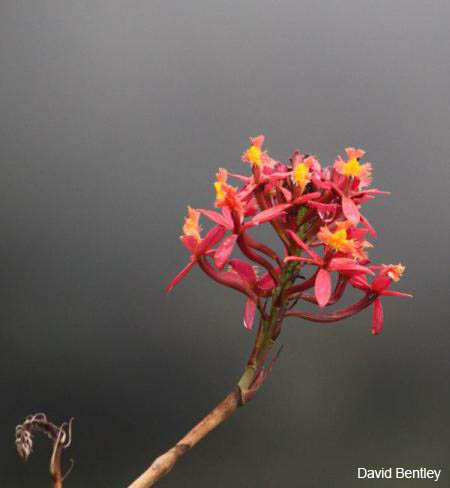
THE INKA TRAIL TOWARDS MACHUPICCHUOne of the most interesting, short and accessible treks in the region is the one leading to the enigmatic Inkan City of Machupicchu. The best time to do the Inka Trail is during our dry season between May to September; however, this does not mean that there is no possibility of getting rains or showers because they simply are unforeseeable even by this season. The first thing when getting ready is to get the necessary camping equipment. When dealing with organized excursions, normally the tour operators supply all that is necessary except for the personal equipment that may also be rented in the several specialized agencies by the Qosqo's downtown area. The elementary equipment items are a tent, a backpack, sleeping bag or blanket, insulating pad, rain gear, trekking boots, food for the 3 or 4 walking days, etc. If the trek is carried out by the traveler's own, then he must be very careful about the equipment to be carried. Besides the items already indicated he must get the following elements: canteen, flashlight, matches, knife, cooking gear with stove, pots, jars, fork and spoon, candles. Food consisting of light products such as instant soups, noodles or spaghetti, fish cans, cheese, ham, rice, semolina, salt, pepper; dry fruits, oats, powdered milk, instant tea, coffee or chocolate; refreshment packs, jam, butter, candies, bread (kept in plastic bags it will be O.K. till the last day). Even more, it will be necessary to take a small personal first aid kit containing a bandage, sterile cotton, gauze, adhesive bandages, analgesics, antiseptic ointment or liquid, diamox or coramina for those who suffer altitude effects, insect repellent, sun screen, Vaseline. Coca leaves are also very useful since that they are used to make infusions or they could be chewed in order help people get adjusted to the altitude, as well as for mitigating tiredness, thirst or hunger. Normally, water is found in all the spots described in this book as campsites. However, it is always commendable to boil the water, or otherwise to use chlorine or any other purification device or tablets to make it drinkable. It is recommended to take light clothing for the sunny days as well as warm ones because in certain sectors the nights may be cold with temperatures under 0° C (32° F). Do not forget a sun hat or cap, towel, toilet paper; shoes must be preferably waterproof hiking boots with ankle protectors. Depending on your interests also carry a photo or film camera, binoculars, sun glasses, compass, a good trail handbook, etc. All the equipment including the food should have a light or moderate weight for the hiker; some few extra grams become heavy and unbearable on the hike. In order to sleep do not leave your belongings outside your tent since in some sectors, especially during the first hiking days some nighttime robberies were reported. It is not recommended to hike all alone, do it always along with some other hikers; there is a Safety Committee in order to grant help to travelers but which is seldom effective. Moreover, it is recommended not to move away from the trail or the signaled way; if you ever have doubts ask the other travelers coming after you. There are some basic rules that must be kept in mind carrying out the trek, such as: - Set your campsite only in the signaled sectors, it is completely forbidden to do it inside or close to the Inkan buildings; - Avoid pollution of the Machupicchu Historic Sanctuary, inside where the Inka Trail is. In the last years there was an enormous deterioration in the trail's hygiene and sanitation; many irresponsible visitors defecate in the ruins or over the trail, or leave their garbage wherever they want without considering that there are many others like them who would like to enjoy an agreeable and pollution-free surrounding. It is recommended that every visitor group should take their garbage out of the Inka Trail or ask their porters to do it, especially all non organic waste; - Setting fires is not allowed and neither is he use of local wood for that purpose; setting fires against the Inkan walls damage them irremediably causing their stones crack; - It is not allowed to gather flowers or other vegetable species; therefore, it is forbidden to spoil flora of the Historic Sanctuary as well as capture or hunt its wild fauna as many of the animal species are endangered. The Machupicchu police are fully authorized to enforce penalties or arrest those breaking the rules. - The Inka Trail fee is U.S. $ 17.00, including one day of visit in Machupicchu. In order to do the hike, today people use mostly two start points: Chillca and Qoriwayrachina or "Km. 88". In both cases it is possible to catch the local train departing Qosqo daily in two frequencies (in the early morning or at noon); in order to get to Chillca it is also possible to take a private car following the road through Urubamba and Ollantaytambo. Trekking from the village of Chillca (Ch'illca is also a native medicinal bush which biological name is Baccharis polyantha) takes normally about 4 days; in this village there is a bridge over the Urubamba River that must be crossed in order to continue towards the west, following the dusty trail that is parallel to the river. Today this is a bridle path, the one existing in Inkan times has disappeared; by that time, there were two trails on both river banks. The first hiking day in this option is relatively easy and serves as a training for the next days; the terrain is almost flat. From some sectors there are great views of the Cordillera of Urubamba (Range of Mountains of Urubamba) and the La Veronica glacier (its original name was "Weqey Willka" -"Sacred Tear"- 5860 mts; 19225 ft). During the first hiking day it is still possible to find small shops where they sell soft drinks, beer and cookies; besides, on the way is the community of Meskay where there is a school, and nearby there are archaeological groups such as Willkaraqay, Kiswarpata and Tunasmoqo. Even further is Patallaqta ("Upper Town" -others call it Llaqtapata-) that was an important Inkan town that keeps remains of "pirka" type walls and farming terraces. The southern part of this complex is named Kusichaka (Happy Bridge) as well as the stream. This is a good spot to camp, otherwise, it will be okay to go on as far as Wayllabamba. When beginning the hike from Qoriwayrachina (Gold Blower) also known as " Kilometer 88", one must pass through the State check point and pay the fee for using the Historic National Sanctuary and then cross the modern bridge built over Inkan foundations. Soon after, the trek is towards the east through the eucalyptus woodland in order to get to Patallaqta and later follow upstream the small Kusichaka river on its left bank towards the south. Further away it will be necessary to cross the small wooden bridge called Hatunchaka (Big Bridge) and the Yunkachinpa community to finally arrive at the settlement of Wayllabamba (Wayllapanpa = Prairie Plain) where there are houses of peasants, a school and some material remains of the Inkan Culture. This is the last spot where it is possible to get some goods and drinks before arriving to Wiñaywayna. From Wayllabamba, that stands over about 2800 mts. (9180 ft.), there is a path towards the northwest that must be taken, following the right bank of the Llullucha stream (Llulluch'a is an aquatic plant with the shape of small dark balls, its biological name is Nostoc S.P.). Over here starts the longest climb of the trail that ends on the Warmiwañusqa pass. From Wayllabamba starts the way up to get to " Tres Piedras Blancas" (Three White Stones) which is a proper space to set campsite close to the Wayruro stream (Wayruro is an ornamental tree that has red seeds with black patches, its biological name is Citharexylum herrerae. In the tourist slang, porters from Ollantaytambo who serve tourists in the Inka Trail are known as "wayruros" because of their red ponchos). Around this zone and upwards is what is named as "Montane Rain Forest" characterized by the abundance of trees such as Intimpa or Romerillo (Podocarpus glomeratus), Q'euña (Polylepis incana), Unca (Eugenia oreophilla), etc. There is also an abundance of lichens, mosses, ferns and orchids of diverse species. Inside this Historic Sanctuary there are more than 30 genera and over a hundred species or orchidacea; likewise, over here it is possible to find many species of wild begoniae. Among some other tree species here are: cedar (Cedrela herrerae), pisonay or coral tree (Erythrina falcata), lambran or alder tree (Alnus jorulensis), laurel (Nectandra sp.), kiswar (Buddleia incana), walnut (Juglands neotropica), sauco or elderberry (Sambucus Peruviana), etc. By the end of the woodland is Llulluchapampa that is another proper campsite over about 3660 mts. (12000 ft.). The temperatures around here are low because it is the beginning of the "High Andean Zone" simply known as "puna" with an abundance of the wild native bunch grass ichu (Stipa ichu). Following the climb is the highest point of the trek in the pass of Warmiwañuska (Dead Woman) over 4200 mts. (13780 ft.). In this pass there is a pile that looks like artificial, possibly it is an "apacheta", that is, a heap of stones and other objects that travelers used to leave as presents in the highest passes. The air is cold over here and in many cases it is possible to get snow; it is recommendable not to stay a longtime in this pass because of its rarefied air with oxygen scarcity. From the Warmiwañuska pass starts a descent through a rough path around which it is possible to perceive the slow formation of a stream that in the bottom of the small valley is named Pakaymayu (Hidden River). By the bottom of the valley the trail is visible without reaching the thick vegetation; this is another of the recommended campsites, over 3600 mts. (11800 ft.). By the middle of the descent and on the left side there is another genuine ancient paved trail that follows almost horizontally on the mountainside surpassing another pass to go down then into the Aobamba Valley; it is necessary to follow an abandoned trail and further away towards the right hand is Sayaqmarka. That last way is not recommendable because the trail is abandoned and in some sectors it disappeared by the effect of natural erosion; it is not used and it has no maintenance, thus it offers many dangers. From the campsite in Pakaymayu starts another climb towards Runkuraqay; this time the hike is over a trail paved with flagstones that offers a lot of safety specially in rainy days. Runkuraqay is by the middle of the way up and has an ovoid shape; possibly the name with which it was baptized by one of Bingham's native guides in 1915 was "Runturaqay" (Egg-shaped Inclosure). The walls of its buildings are of the "pirka" type. Because of its location and the layout of its rooms, it seems that it served as a "tambo" (lodge for travelers); this is another possible campsite. Continuing the climb through the cobbled stairway, on the trail's left side there is a very small lagoon called Yanaqocha ("Black Lake"), on the right side and on an upper level is another one having the same size. In this zone occasionally it is possible to see Guemals or Tarucas (Hippocamelus antisensis) that come down in order to drink water, and Mountain Vizcachas (Lagidium Peruvianum). Inside the Machupicchu Historic Sanctuary it is also possible to find species such as the Puma or Mountain Lion (Felis concolor), Andean Cats (Felis jacovita), Ocelots (Felis pardalis), Hog-nosed Skunks (Conepatus rex), South-American Foxes (Dusicyon culpaeus), White Tailed Deer (Odocoileus virginianus), Tanka or Dwarf Brocket Deer (Mazama Chunyi) -endangered specie-, Weasels (Mustela frenata), Pudus (Pudu mephistophiles), Tayras (Eyra barbara), Amazon Otters (Luthra incarum), Spectacled Bears (Tremarctos ornatus) -endangered specie-; among the main birds are the Andean Condor (Vultur gryphus), K'illichu or Sparrow Hawk (Falco sparverius), Bat Falcon (Falco rufigularis), Torrents Duck (Merganetta arnata), Cu-cu (Momotus momota), Quien-quien (Cyanocorax inca), Cuvier's Toucan (Ramphastos cuvieri), Chiguanco (Turdus chiguanco), Razor-billed Curassow (Crax mitu), Chinalinda (Phalacoboenus albogularis), Andean Gull (Larus serranus), Yanavico (Plegadis ridwayi), Cock of the Rock (Rupicola Peruviana) -endangered specie-. More over, there are vipers, lizards, diverse amphibious, butterflies and insects, etc., etc. If you decide to go into the undisturbed forest, far away from the trail, be aware of some dangers like finding lethal snakes such as the bushmaster (Lachesis muta) or the viperine fer-de-lance (Bothrops atrox) which possesses a virulent venom that is destructive of tissue destroying blood cells and mucous membranes as well. At the end of the climb is the second highest spot named Runkuraqay Pass, over 3900 mts. (12800 ft.). From this pass starts another steep descent towards Sayaqmarka. By the middle of the way down, and on the right side there is another interesting green colored lagoon having a lot of algae, it is known as Q'omer-qocha (Green Lake). Sayaqmarka is an archaeological group located over 3500 mts. (11500 ft.) and was explored by Bingham's expedition in 1915 which native guides named it "Cedrobamba" ("Cedropanpa" = Plain of cedars). By the end of 1941 a Viking Fund expedition headed by Paul Fejos explored the area and rebaptized it as "Sayaqmarka" (Steep Spot) considering its geographic location almost by the end of a mountain spur that dominates visually the Aobamba valley. In this complex there are different constructions that are somewhat intricate because of having been adapted to the rough mountain shape; in spite of the difficult environment there is also an aqueduct capriciously carved on the mountain crest, fountains that seem to have had a ritual purpose, narrow streets, a semi-ovoid dominant building, etc. Because of the area where it is located, this site must had a duty almost strictly administrative and ceremonial; perhaps for management of the territory and the nearby roads. Thus, it is possible that it could have been inhabited by soldiers, state officials, and priests, who were not farmers as there are no farmlands around. Normally this site has little maintenance, therefore, occasionally one may encounter vipers or some other animals; more over, around here there are almost always large amounts of very small biting mosquitoes called "manta blanca" (white blanket) that are almost invisible but they exist by the millions and have good resistance against repellents. This is another place that serves as campsite. Near Sayaqmarka, on the right side of the trail there is another building that must had a close relationship with the "Steep Spot", it is Qonchamarka (Cooking Stove Spot) which is also built with "pirka" type walls, its original duty is unknown. From Sayaqmarka departs a somewhat abrupt trail towards Machupicchu, and very few kilometers away is a short humid and swampy plain named Chakilqocha (it should be "Ch'aki Qocha" = Dry Lake) that is often used as a campsite. Farther away, continuing on the trail carefully paved with flagstones, there is a wide and comfortable tunnel carved in the mountain rock; it is about 20 mts. (66 ft.) long and has carved steps, walls and floor. Advancing through the comfortable trail the traveler gains altitude in order to get to Phuyupatamarka that is found over 3680 mts. (12070 ft.). Likewise, that archaeological group was "discovered" by Bingham in 1915 who named it as "Qoriwayrachina". But, in 1941 Paul Fejos and his expedition rebaptized the site with the name of "Phuyupatamarka" (Spot over the clouds), because it is almost always over the clouds and mist formed in the valleys around. It is placed in a space that dominates visually a broad territory and must have been an important religious and administrative core. Its features include a superior almost ovoid platform, aligned fountains that must had a religious duty with well-disposed channels and water that is still flowing; very well carved stairways, rough wall constructions, terraces, etc. From this spot there are two trails in order to go down to Wiñaywayna; one of them is projected almost horizontally towards the west and then it descends abruptly to the next archaeological group (this trail reaches also "Wayraqpunku" -Windy Doorway- on a mountain pass, where there was a project in order to build a modern hotel); that way is not used any more because of the dangerous descent. The other trail, cleared up in 1983 goes down from the western end of this site, this one is a flight having so many and very well built steps by the middle of the thick forest where there is also another small tunnel carved in the rock; by the end of this Inkan path there is another dusty and zigzagging one built by those who raised the electricity towers by the 1960s. Even lower is the Wiñaywayna Visitors Center consisting in a group of concrete and red roof buildings, that offers basic lodging and eating facilities; however, it is possible to camp around here. Towards this center's southeast is the Archaeological Group of the same name that is practically hung over the Urubamba canyon. Wiñaywayna is an important archaeological group near Machupicchu, over an altitude of 2700 mts. (8860 ft.). It was found by Paul Fejos in 1941, and subsequently in 1942 the Peruvian scholar Julio C. Tello baptized the site as "Wiñaywayna" (Forever Young) after the Quechua name of an orchid specie (Epidendrum crassilabium). The Epidendrum genus has here about 20 species of white, red, yellow or violet beautiful flowers that are abundant in the zone; another very common genus is Pleurothalis. In Wiñaywayna there are diverse buildings among which is an upper semicircular one that is traditionally known as the "palace" or the "tower", built partially with carved stones. Towards the right side of the descending stairway there is a range of 10 successive ritual fountains that are classical in every important settlement. Towards the north is the farming sector with a large amount of artificial terraces; lower are some other buildings on the precipice's edge with "pirka" type walls from where there is a nice view of the mountains' lower part and the valley. Toward the northeast of Wiñaywayna and in an upper level is Intipata (Spot of the Sun); an archaeological site formed mainly by agricultural terraces. Down, in the valley's bottom, on Km. 107 of the railway Qosqo-Quillabamba is the dam for the Machupicchu Hydroelectric Power Plant, constructed between 1958 to 1962. From that dam there are a couple of 3 Km. long tunnels drilled in the Machupicchu granite mountain; they carry the water of the Urubamba River to the other side of the mountain in the San Miguel sector. Taking advantage of the difference in altitude the water is transformed in 110,000 KW of electric power, for the Qosqo and Puno departments. Near the dam is the Archaeological Group of Choquesuysuy (Gold-ore Sifter) that includes some few buildings and farming terraces. The last tract of the hike from Wiñaywayna is through an impressive somewhat horizontal trail, carved in the mountain face in which on the right side there are deep precipices. Almost by the end of the relatively flat trail there is a stairway arising in order to finally get to Intipunku (Sun Gate), located on the pass over an altitude of 2650 mts. (8700 ft.). From Intipunku you will get for the first time a panoramic view of Machupicchu. In the Inkan Society this must have been something like a watchtower and customhouse in order to enable checking those wanting to enter Machupicchu, as well as for its protection.
|