|
|
|
|
Preface and General
Information
|
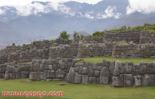
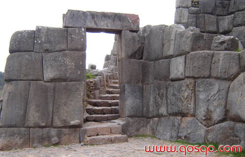
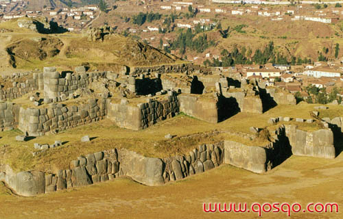
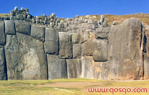
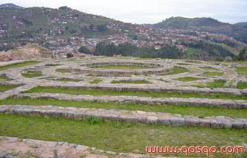
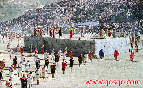
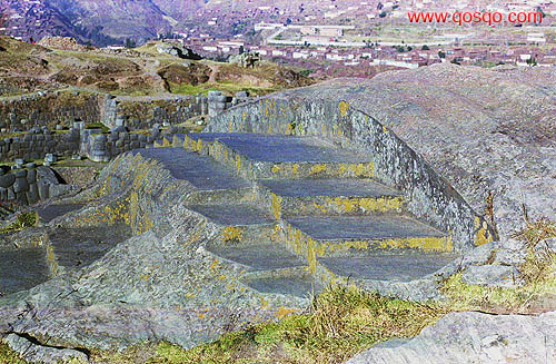
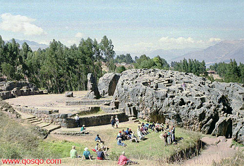
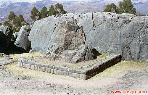
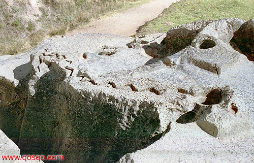
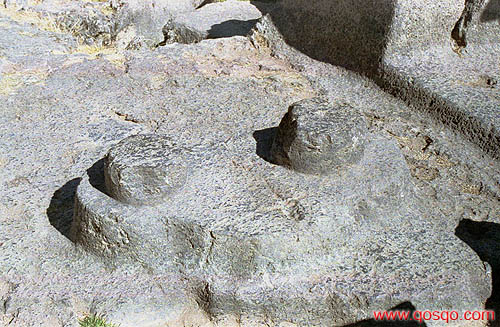
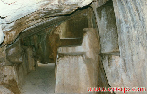
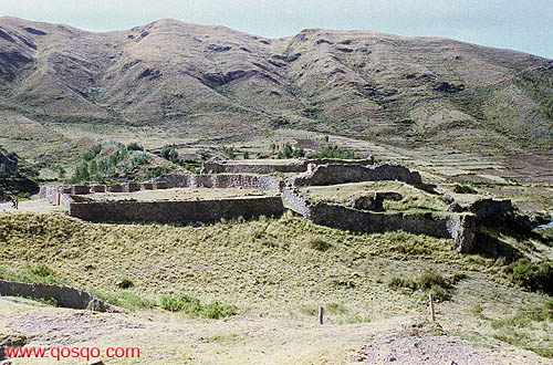
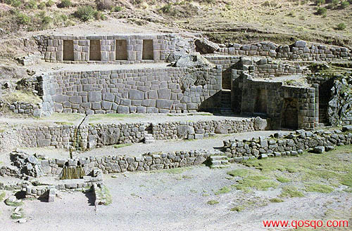
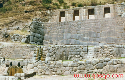
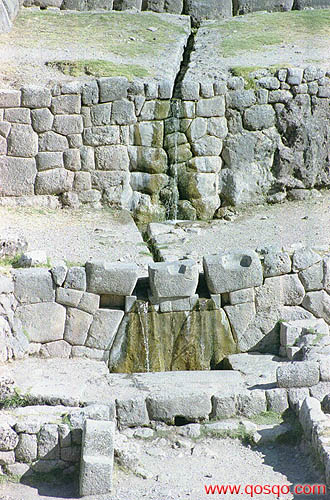
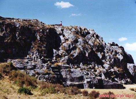
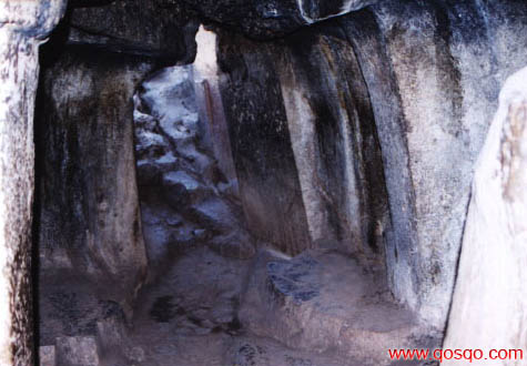
S A Q S A Y W A M A NOne of the most imposing architectonic complexes inherited from the Inkan Society is precisely Saqsaywaman, which because of several of its qualities is considered as one of the best monuments that mankind built on the earth's surface. When the Spanish conquerors arrived first to these lands; they could not explain themselves how Peruvian "Indians" (ignorant, wild, without any ability of logical reasoning, one more animal species according to conquerors) could have built such a greatness. Their religious fanaticism led them to believe that all that was simply work of demons or malign spirits. Still today, many people believe in the inability of ancient Quechuas to create such a wonder, so they suggest that they were made by beings of some other worlds, extraterrestrial beings with superior technology that made all that possible. However, our history and archaeology demonstrate that those objects of admiration are an undeniable work of the Inkas, Quechuas, Andean people or however pre-Hispanic inhabitants of this corner of the world would be named. The original name of this site causes controversy existing many interpretations. The form stated by tradition is Saqsaywaman (in the native language accent is in "wa") that comes from the Quechua verb "saqsay"= to satiate or to get satiated, and the noun "waman"= falcon; thence, in a narrow sense as it is found with the imperative verb, it means "get satiated falcon". Some others believe that the name is Saqsawaman that is derived from "saqsa"= marbled, speckled, and "waman"= falcon; in the Quechua language the noun goes after the adjective, thus, it would mean "marbled falcon". Likewise, history demonstrates that Qosqo City had the shape of a puma (cougar or mountain lion) which head was formed by this complex. So, its name is perhaps a deformation of Saqsauma that comes from "saqsa"= marbled, and "uma"= head; meaning like this "marbled head". Its construction was began by the ninth Inka: Pachakuteq, that is, after 1438. In spite of the many criticisms he got, Garcilaso Inca de la Vega (1539-1616) gives most of the information and better describes the monument. Garcilaso was son of Isabel Chimpu Oqllo, a Quechua princess who was first cousin of Inka Atawallpa, and the Spanish Captain Garcia Lasso de la Vega, related to the Spanish nobility. Garcilaso wrote that its construction lasted about 50 years until the Wayna Qhapaq's period; so when Spaniards arrived it was completely finished and fully in use. Pedro Cieza de Leon asserts that for its construction about 20 thousand men were brought and that the different towns must have sent "necessary supplies" for their sustenance. That was not a permanent crew, because workers were replaced temporarily. In the Inkan Society there were no slaves as in the Old World. Since money was not known over here, people had to pay taxes to the Inkan Government as labor or as divers goods such as food, clothing, weapons, etc. Today, when reading books, brochures or some other written material about this site; normally the name "Saqsaywaman Fortress" is found. Chroniclers state that Saqsaywaman was built in order to put it ahead of the city's Sun Temple, Cieza de Leon indicates that it was a " Royal House of the Sun", Garcilaso says that it was a " ...Sun's House, of war weapons, as well as it was a temple for prayers and sacrifices". Thus it is evident, that Saqsaywaman had a preponderant religious duty, that is why it was very well protected. Confusion starts in 1536 when Manko Inka gave it a warlike duty in order to fight against the invaders that had occupied the downtown area of the city. In this place Juan Pizarro (Francisco's brother) received a blow with a stone that sent him to his grave; in the Saqsaywaman siege also appeared a Quechua warrior whose name according to tradition was Qawide or Kullas (an anonymous nobleman whose real name does not matter) that defended with amazing bravery the Inkan position, exalted even by Spanish chroniclers. Before all that, in 1535, in this same spot Manko Inka or Manko II was secluded, humbled and ill-treated when claiming to the Spanish conquerors restitution of his society. The same Garcilaso wrote that in his childhood he used to visit and play in this spot, that was a very complex and broad labyrinth because of the existing amount of underground passages and doorways. He indicated that it was necessary to have the help of a guide for its visit or the use of a ball of yarn which tip was tied to the entrance; like this a person could get out guided by the yarn. Originally there were three "walls" or "bulwarks" which foundations are still seen today; they are the most spectacular remains of that fabulous building that according to chroniclers did not have any comparison in the old world. They are three parallel walls built in different levels with limestones of enormous sizes; zigzagging walls that because of their appearance it is suggested that they represent the "teeth" of the puma's head that the complex represented. The boulders used for the first or lower levels are the biggest; there is one that is 8.5 mts. high (28 ft.) and weights about 140 metric tons. Those boulders classify the walls as being of cyclopean or megalithic architecture. Some authors believe that the three walls represent the three levels of the Andean Religious World: beginning from the bottom would be the Ukju Pacha (underground stage), the Kay Pacha (earth's surface stage) in the middle, and the Hanan Pacha (sky stage) on the top. Besides; those levels are identified with their three sacred animals: the Amaru or Mach'aqway (snake), the Puma (Cougar or Mountain Lion), and the Kuntur (Andean condor). Because of the zigzagging shape of the walls, some authors suggest that they represented the Illapa god (thunder, lightning and thunderbolt). It is possible that all the previous elements related to their religion would not be excluding, because there are divine interactions, and as it is known "three" was a key number among Quechuas. What is left from the three walls is made with limestones that in this case were used just in order to built the bases or foundations. The main walls were made with andesites that are blackish igneous stones which quarries are in Waqoto on the mountains north of San Jeronimo, or in Rumiqolqa about 35 Kms. (22 miles) from the city. Limestones are found in the surroundings of Saqsaywaman but they are softer and can not be finely carved as the andesites of the main walls that were of the "Sedimentary or Imperial Inkan" type. Destruction of Saqsaywaman lasted about 400 years; since 1536 when Manko Inka began the war against Spaniards and sheltered himself in this complex. Later the first conquerors started using its stones to built their houses in the city; subsequently the city's Church Council ordered in 1559 to take the andesites for the construction of the Cathedral. Even until 1930, Qosqo's neighbors just paying a small fee could take the amount of stones they wanted in order to build their houses in the city: four centuries of destruction using this complex as a quarry by the colonial city's stone masons. Garcilaso wrote that on the top of the three "walls" or "bulwarks" there were three strong towers disposed in a triangle. The main tower was in the middle and had a circular shape, it was named as Moyoc Marca (Muyuq Marka), the second one was named as Paucar Marca, and the third Sacllar Marca (Sallaq Marka); the last two ones were rectangular. Between 1933 and 1934 thanks to an authorization of the Peruvian Parliament in order to commemorate the fourth century of the Spanish refoundation of Qosqo, some works were done emphasizing on cleaning up and putting in service deteriorated monuments. Those works were led by Luis E. Valcarcel, who after having read Garcilaso's books dug on the top of the three walls, and found the towers' foundations described by the Cusquenian Chronicler, thus, it was demonstrated the truth of the document about the topic. About the main tower or "Muyuq Marka"; today, there are three concentric rings that were the foundations of its three stories or levels; its original height is unknown but it must have been important because it dominated the whole city. Even more, its walls were adorned with inlaid elements of the regional flora and fauna, in natural size and made in gold and silver. This tower's central portion was used as an abundant water reservoir for supplying the complex; the water was harnessed from springs in the higher part of the northern mountains where there are also several reservoirs; and transported to the "Muyuq Marka" through an underground channel made of carved stones coated with clay. Wet clay made its interior surface impermeable setting it up as a real siphon. Even today, the carved water channels are found in the surface of the tower's foundations. More over, between the concentric rings there are foundations of 12 small transversal walls that served in order to protect the building from the enormous pressure of water stored up in the middle; because of presence of those transversal foundations some dreamers refer to the "Muyuq Marka" bases as "solar clock". The last decades have also witnessed the apparition of several "prophets" practicing a pseudo Andean Esotericism or Mysticism. They make believe to unaware people that the axle of the circular bases is the special spot where a person can get "recharged" with "positive energy", and magnetic and spiritual power; and that it is a phonic space that produces different echoes. Many authors suggest that those foundations represent the "eye" of the "marbled head". In front of the three walls is the plaza of " Chukipanpa" (Spears Plain), that surely served in order to carry out different special open-field ceremonies by the very exclusive and important persons dwelling here. Although, it is argued that the complex could easily house about 5 thousand persons, this site must have been used only by very few persons. In Inkan times the towns and cities were inhabited just by noble people while common people lived in far away places and near their farmlands. Inside the towns and cities there were Waqas (shrines) that were used only by the Inka and priests. Thence, all temples or sanctuaries like Saqsaywaman were very exclusive and very well protected, not because they were fortresses but because of their religious duties. Since 1944 at the "Chukipanpa" plain, every June 24th the Inti Raymi (Sun Festivity) is staged. That was the most important festivity in Inkan times; it was originally performed at the winter solstice in the Southern Hemisphere, that is, on June 21st (a broad information about this festivity is given in the Inti Raymi chapter of this book). Also in the same "Chukipanpa" or "spears plain" annually the Warachikuy festival was carried out; Spaniards called it "party in order to arm gentlemen". It was something like an "initiation" ceremony in which young men got their first Wara (breechcloth). In order to get the "wara" the young men had to pass different athletic tests and sham battles; after successfully passing all tests they got their citizenship and ability for getting married and warring. What is seen today in Saqsaywaman is not an isolated unit but part of a broad complex comprised of several "Wakas", different civil buildings, reservoirs, aqueducts and a considerable territory today known as "Saqsaywaman Archaeological National Park". Towards the Chukipanpa's north there are remains of terraces and diverse walls that were part of the complex. On top of those semi-destroyed terraces is a "stock" protrusion, that is, a natural diorite formation known as " Suchuna" ("sliding spot"; for some people, that formation served as playing toboggans for kids). On its upper side it has some finely carved steps known as the "Inka's Throne"; carvings that according to various authors have some relationship with some key numbers and solar observations. Also in this spot there is a wooden cross memorializing the arrival of Pope John Paul II, who said mass right there in 1985. Further to the north, some remains of a magnificent circular water reservoir were discovered a few years ago; because of its quality that reservoir must had a religious duty. According to some studies, in Inkan times there were many fountains, reservoirs or water tanks used as mirrors during clear nights in order to observe and study the stars and constellations. Possibly, the reservoir found over there also had that duty. Towards the northeast of the reservoir there is a karstic formation, an effect of the dissolution of calcium carbonate contained in limestones, caused by water that also drilled a tunnel known as small " Chinkana" ("spot to get lost"). That passage shows areas that were modified or carved by Quechuas; it is supposed to be a temple dedicated to the "Ukju Pacha" or "Underground World" and the cult of snakes and corpses. Even further to the north is the big "Chinkana" under a huge carved boulder that local people know as the " tired stone" (according to tradition it never arrived to the spot where it was supposed to serve), as many people argue it is a large "chinkana"; but today it is flooded and closed. Q'ENQOThat is an archaeological group found towards the east of Saqsaywaman, at an altitude of 3600 mts. (11800 ft.); over a protrusion of the Yunkaypata limestone formation that was formed in the Cretaceous about 80 million years ago. Limestone is a sedimentary rock with marine origins, found here because in prehistoric times the Qosqo Valley was a huge lake named Morkill that on its eastern side went as far as Angostura. The rock surface is very irregular and known as "karstic landscape" that is formed due to the dissolution by water of calcium carbonate concentrations contained in the rock. The original name of that site is lost and the current one seems to have been used since the XIX century. Q'enqo is a Quechua word that means "labyrinth", "twisted" or "zigzag". This must be one of the 365 adoratories that should have existed in the Qosqo Valley. Presides this site the "plaza" or open space that many call "amphitheater" that served in order to carry out different ceremonies in presence of their idols and mummies that occupied the 19 trapezoidal niches that are partially destroyed today. Those niches were high enough to let a person stand up inside, this is why it is suggested that they also served to keep the Wayke of noble people (wayke = brother); that is, human shaped idols in natural sizes and made in precious metals that according to local belief contained the spirits of the represented persons. In front of the niches there is an enormous Sacred Rock that because of its location must have had a special meaning; it has a base of well carved stones in which two rows are missing. Scholars suggest that this rock was an impressive sculpture having the shape of one of the Inkan Gods; perhaps that of a feline or a snake. But, as it was a god for the Quechuas, it was totally broken and deformed when Spaniards performed the sadly famous " Idolatries Extirpation"; by which they destroyed everything opposing Christianity and having any relationship with Inkan Religion. Some audacious people do not hesitate arguing that this sculpture was a phallic symbol. Towards the plaza's northeast side, there are remains of one liturgical fountain that contained abundant and good water. Unfortunately, today it is dry and semi-demolished after that the water was channeled and taken to the Cusqueña's brewery that boasts of producing beer "made with the Inkas' water". On the top of the rock protrusion there are many carved areas that surely served as bases for some other buildings that were demolished. There are many steps carved in the natural rock, remains of zoomorphic sculptures specially those of a bird and a quadruped. There is also a very interesting Phaqcha (fountain) consisting of a bowl on its upper side and a zigzagging small channel that is branched into two in its lower end. It is suggested that this device served in order to carry out divination rituals: in the upper cup they probably poured liquids that could be "Aqha" (maize beer), or perhaps blood of animals sacrificed inside the semi-underground chamber; the liquid flowed through the zigzagging channel and then followed through one of the two branches that must had different or opposing meanings (perhaps positive and negative). Thus, they could foretell diverse happenings; it seems that the present-day name of the monument comes from this zigzagging channel. Crowning the top of the limestone formation there are two carved cylindrical uprights over an ovoid pedestal. They are known as the Q'enqo's Intiwatana, that it's supposed was used as a solar observatory along with some other elements. The Intiwatana was used in order to measure the different variations of the sun, fix solstices and equinoxes, calculate seasons, etc., with the aim of facilitating farming activities. It is obvious that another of its duties was for worshipping the Sun God and maybe some other astral bodies. It is surprising that two transversal sides of those two uprights indicate exactly the magnetic north, what is easily proved with a compass; something similar is observed in Machupicchu, thence, it is probable that Quechuas also knew directions because many coinciding elements are found. Today it is also possible to read or listen to non serious stories telling that originally those two uprights were used for performing sacrifices or also for checking the virginity of girls (according to this they were kept standing up over the carvings and forced to urinate, if they did it right into the small carved groove that is by the middle then it was because they were virgins, otherwise they were not). People very often create funny stories and theories that without any doubt are a product of their dreaming imagination. In the lower part of the huge boulder there is a narrow passage carved on its lateral surfaces following the natural rock fault. Even lower is the so-called "Sacrificial Chamber" that was also carved taking advantage of a small naturally formed cave. Inside the cave; towards the east is a trapezoidal niche surely used in order to keep elements and tools for performing sacrifices. Towards the west of the cave is an opening in the rock as a window facing the narrow passage, opened surely in order to have some more light inside the dark cave. In the cave's central part there is a sacrificial stone altar where perhaps animal sacrifices must have been performed for divination or ceremonial purposes. Human sacrifices were seldom practiced in the Inkan Society, that is why for example, in the Inti Raymi, the most important ceremony in their festivity calendar just a llama was sacrificed. Towards the southwest of this sanctuary is another one having a spheroid shape today known as Q'enqo Chico (Smaller Q'enqo). Both sites had apparently a very close relationship. Q'enqo Chico is surrounded by a "cellular" type wall that must have been higher; inside it there are some stairways, aqueducts, niches and some other elements that had religious duties. PUKA-PUKARAIt is an archaeological site found at kilometer 8.5 (5.3 miles) on the road leading to P'isaq and the Sacred Valley of the Inkas; at an altitude of 3750 mts. (12300 ft.). Its name is compound and comes from two Quechua words: "puka"= red, and "pukara"= fortress. So "Puka-Pukara" means "Red Fortress" (perhaps because its limestones acquired a reddish color, since the soil over which it was built is also reddish as it contains a lot of iron). The existing wall type over here is "cellular" with small and medium polygonal or irregular stones. It occupies a very strategic space over a natural mountain spur for facilitating observation and control of a broad territory. Likewise, it also had visual communication with the small "pukara" in Tambomach'ay about one Kilometer away (0.62 miles). It was supposed to protect Tambomach'ay that was an important palace in Inkan times. But besides, because of its architectonic layout and existence of fountains, aqueducts and several rooms, and its closeness to the ancient trail it was used a small "tambo" (the trail is seen winning the pass on the northern mountain leading to Huch'uy Qosqo and Calca in the Sacred Valley). That is, it was also a collective lodge offering shelter and food for travelers, as well as for the retinue escorting the Inka in his retirement in Tambomach'ay. TAMBOMACH'AYThe present-day name is a deformation of the original Tanpumach'ay , that is a compound and comes from "tanpu"= lodge and "mach'ay"= resting place. This place and its name are consigned in different chronicles, which also indicate that originally it was an exclusive relaxing and retirement palace for the Inkas. According to Polo de Ondegardo, it belonged to Inka Yupanqui who used it when hunting; which is probable because even today, on the mountains surrounding it there are many wild animals such as deer, pumas, foxes, partridges, etc., and in Inkan times perhaps also wild South-American cameloids. The Inka was considered as the Son of the Sun, thence, he was a living god. Thus, his house or palace also had a sacred character, which is demonstrated as this place is considered in the chronicles as Waqa (Sanctuary). What is left from the building is leaning against the mountain face and constructed with medium polygonal limestones, with the "cellular" wall type. There are four trapezoidal niches in the upper wall and two other ones lower to the right; all with monolithic lintels. Those niches were probably used in order to keep Inkan idols as well as mummies. There are three Ceremonial Water Fountains too. They were built in two different levels and had a strictly ritual duty when considering that Unu or Yaku (water) was an important male deity that fertilized the earth. Thus, water had always special temples for its cult in all the important religious complexes. The water found here is clean and crystalline; its source is unknown and it is conducted through an underground channel. It is supposed that the water spring is located toward the west, in the skirts of the range of mountains known as " Senqa". This water being clean and crystalline is inoffensive for us, people who dwell in the region because of our custom and acclimatization; but it could not be so good for foreigners. Many authors call this site "Inka's Bath", others "Ñusta's Bath" (ñusta = princess); some others with certain audacity say that these liturgical fountains are "Eternal Youth Fountains" or "Fertility Fountains" inducing visitors to drink the water. There is not so much knowledge of the practice of ceremonial baths among Inkas; however, they could have existed as a way to purify the body. On the other side, in front of the fountains there is another building also made with carved stones. Because of its location it must have been a point of protection and vigilance; that is, it was a small "pukara" from which upper side there is visual communication with Puka-Pukara (Red Fortress). Around here, today, there are frequently many beggars; peasant kids and women that find in the tourists an easy income source. They are an undesirable product of tourism development in the region; since that in the traditional Andean Society it is impossible to find beggars because their social relationship is based in patterns of mutual reciprocity. In certain cases those beggars offer to tourists small bunches of "muña" (Minthostachys spicata), a native mint plant that when rubbed in the hands emits its fragrance that when breathed offers relief for those suffering from nausea, dizziness, headaches or other undesirable effects of high altitudes. Besides, that herb is also used in order to make medicinal infusions for diarrhea and dysentery due to colds; the leaves used as plaster are an efficacious anti-inflammatory. LAQO(SALONNIYUQ, SALONPUNKU)It is an interesting archaeological group found approximately 1 Km. (0.62 miles) away northeast from Q'enqo by the existing trail (today a car way). Likewise, it is possible to get to that spot through a dusty road branch from km. 6 of the Qosqo - P'isaq road. In the popular knowledge this site is also called "Moon Temple" or "Monkey's Cave". It is located on the ancient Inkan Road towards the Antisuyo, and surely it was also another of the "Wakas" or adoratories reported by chroniclers. Its original name is lost, that is why today it is known with several names. It is placed over a gray limestone protrusion of the Yunkaypata Cretaceous Formation. The natural rock was carved all over its surroundings showing a large amount of stairways, niches, foundations of some other buildings, two birds very similar to those found in Q'enqo and a quadruped, of which the heads were mutilated. Also on the upper side there is an "Intiwatana" or interrupted-conical (it has no vertex) solar observatory, sculpted in the in-situ rock. In the lower part there is a passage communicating the two faces of this shrine that was partially carved taking advantage of the natural fault. Besides, there are two carved rooms inside the great rock which because of the elements they contain must have had strictly religious duties. The second room (the upper one) is the most interesting and has a great snake carved in its entrance and, inside it a quadruped with a broken head. Deeper inside there are niches, platforms and toward the ceiling an interesting skylight that according to popular belief it was a moon temple. At midnight of the full moon closest to the winter solstice the cave's interior is fully illuminated by light going through the skylight. Today, this spot is mainly visited by "mystics" and "esotericists" who carry out sometimes circus-like ceremonies willing to emulate to the real Andean Religion priests. This same spot has become famous during the last decades as it is preferred by confused young people that in the full moon nights visit it for a pilgrimage of "alcohol, sex and drugs". K'USILLUCHAYOQIt is located a half Km. south of Laqo, always on the ancient Inkan Road toward the Antisuyo. Its original name is lost too, today it is named as K'usilluchayoq that translated into English would be "Spot having a Small Monkey" (Kusillucha: monkey in diminutive). It is likewise, an archaeological complex mainly carved on a limestone protrusion that has a lot of karstic surface. On the Inkan Road side there are remains of aqueducts and a fountain having two spillways; which because of the work quality must have had a ceremonial duty and perhaps as well as for supplying travelers. In the lower part of this site there is a protrusive carved stone that was badly hit and broken and which according to many authors must have represented a toad or frog. In the rear side of that stone there are high relief carvings with zoomorphic shapes that seem to have been monkeys and snakes. In this site are also deteriorated remains of a monolith that seems to have represented a feline. There are, more over, carvings with different shapes that corresponded to foundations of some other elements and buildings.
|