|
|
|
|
Preface and General
Information
|
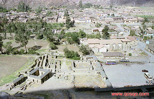
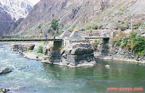
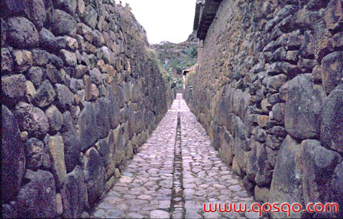
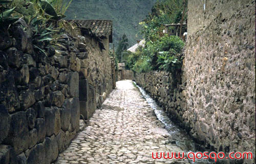
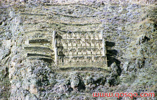
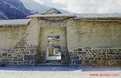
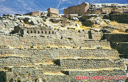
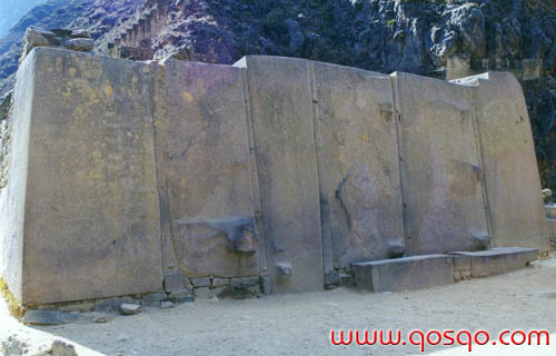
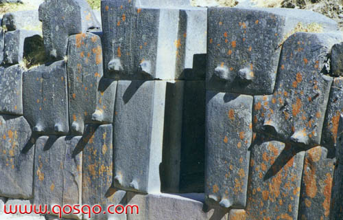
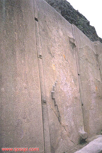
O L L A N T A Y T A M B OThe whole complex is another National Archaeological Park. It is located in the Ollantaytambo district, province of Urubamba. The town is about 76 Kms. (47.2 miles) away from Qosqo by the road Chinchero - Urubamba and about 68 Kms. (42.2 miles) by railway; at an altitude of 2700 mts. (8856 ft.). It is a very vast complex which central part is in the town and its surroundings; traveling from Qosqo, from Pachar there is a large amount of farming terraces that are already part of the complex. Those terraces are deteriorated and most of them abandoned; it is sad to observe that the enormous work for constructing them, today is not appraised with some minimum conservation policies. The water that irrigated them does not flow any more. Their stone aqueducts that were a master work of engineering were extended by many kilometers; but, today they do not exist any more in most of the cases. The reason for that, is simply that today no one is preoccupied with keeping them and because we had three centuries in which conquerors were not interested in agriculture but only in mining gold and silver. Farther down are the strongholds of Choqana on the left bank of the Urubamba River, and Inkapintay on the right bank; they were part of the complex protective system for the Inkan urban core. Advancing downstream are the foundations of an Inkan Bridge, its central base is impressive and was made with huge stone blocks. Before that central base there are two enormous boulders placed for protecting it efficaciously as a mole breaking waters of the river into two. Likewise, on both river banks are the two solid lateral bases of that bridge. Originally, that was a suspension bridge made with braided fibers of "ichu" the local wild bunch grass, or maguey (Agave americana). Because those materials do not last forever the bridge must have been renewed annually. Going on by road, about ½ Km. away from the bridge is the great ancient main gate of the Ollantaytambo Inkan City; it was part of a surrounding wall and is named today as " Llaqta-Punku" (Town Gate) Ollantaytambo is a compound Quechua word that is derived from " Ollanta" that is a personal name, and " Tambo" that is a Spanish form of " Tanpu" that refers about a city that offered lodgings, food and comfort for travelers. "Ollanta" is the name of an Inka Captain whose history was kept as an oral tradition and written as drama by Antonio Valdez, a priest from Urubamba, by the middle of the XVIII century; it was adapted for a theatrical play and opened in 1780. It is apparently since then when "Ollantaytambo" (Ollanta's tambo) began being used to name the town where events of the drama were carried out. The Ollantay Drama is considered as a classical work of Quechua literature and tells the story of a captain named Ollanta, extraneous to the Cusquenian nobility and who formed part of Inka Pachakuteq's army. He was distinguished among the others because of his bravery and great skill, but had a secret love affair with the monarch's daughter named Kusi Qoyllur. When trying to marry her officially his request was considered illegal because the rules in force forbade marriage between persons of different social status. Disappointed the young captain went deeply into Ollantaytambo and incited its population to rebellion against the imperial army, causing a war for a whole decade. He was finally captured thanks to a trick of captain Rumiñawi who appeared as having been vexed and thrown out from Qosqo and succeeded convincing Ollanta in order to get asylum; but, during the night when everyone slept he opened the city gates allowing the Qosqo army's entrance and the capture of Ollanta who was taken to the capital. Fortunately for him, when he arrived in Qosqo the Inka Pachakuteq was already dead, his son being the new sovereign who was told about the true story, and with wise clemency allowed the marriage of the two lovers from whose old relationship a girl had been born and whose name was Ima Sumaq. It is a story with a happy ending that nowadays is very popular in Peruvian schools that in many cases stimulate its performance. Ollantaytambo was a very important fortified city, built as a "tanpu" and also in order to enable control of the roads toward the "Antisuyo" (jungle). According to many historians also in order to allow protection of the great Inkan Capital from attacks of the "Antis", their worst enemies. Today, its name as "fortress" is common, which in practice is improper because it did not have just a warlike or protective duty; but, that of a complex city with an ample urban sector and religious temples. As a fortified city, it had some protective elements, among them a protective wall with few entrances surrounding the town, many "pukaras" or strongholds and watch towers strategically located. Besides, for the noble population dwelling in this city there was a very ample and well planned urban sector, a plaza surrounded by important buildings and toward the town's south an impressive "Kallanka"; that is, a building which dimensions are colossal and completely roofed. It served as a lodge and perhaps also as barracks for the numerous army of the region. The present-day town is located in the same site where the urban sector was in Inkan times. It is really interesting because it is the only spot in Peru where it is possible to find people living in the same buildings that served as homes for the nobility of the Inkan Society. Some of its narrow streets still keep their water channels where very clean water flowed for the population use; they are by the middle or at one side. The streets still maintain their Inkan names. The town was divided in rectangular blocks with a very well planned geometrical layout giving the impression of being a town designed by modern architects. Every block was compound of two "kanchas" (apartments); the street gates had double jamb doorways which indicate that those were real palaces with rooms around a central patio. At least the lower part of the buildings is original and made with "pirka" type walls that were covered with a clay coat and possibly also had mural paintings. Today, their thatched roofs were replaced by red tiles and it is possible to breath a certain air of modernity as the town has electricity and tap water; but in short, the town has still an Inkan taste. Some decades ago in Ollantaytambo, a worldwide meeting of the "Indian" representatives was carried out and they declared this town as the " World Capital of Indianity". By that time there were some efforts willing to help for an effective conservation of original structures; in practice, it is so little what was and is done for that purpose, and it is so sad to prove that many of its innate elements are being lost slowly. Towards the town's east is the Pinkuylluna hill (pinkuyllo = wind musical instrument similar to the "quena" or Andean flute) where an imposing huge building stands out and about which there is a lot of myth. Some very imaginative "scholars" argue that it's been a school, a hospital some others, jail others, and even a hurling precipice!; according to archaeology and the Inkan architectonic characterization it was a "Qollqa" or "Pirwa"; that is, a granary or storehouse for food, clothing and weapons for local army. It has many doorways and openings that allowed ventilation, and surely they were built up there to enable protection of the stored goods. Likewise, some other smaller buildings are located in outstanding spots or angles of the mountain that served as watchtowers for controlling movement of persons in the valley. Toward the western end of the town and crossing the Patakancha (Upper Inclosure) stream is the great Plaza known as Mañay Raqay (Pleas Plaza) which seem to keep its original name, surrounded by sun-dried mud-brick buildings that were very important in their epoch. Towards the west of this plaza is the entrance to the religious sector; in the lower part there are terraces that served for two purposes: they were farming terraces and had an aqueduct by their southern end; likewise, they served in order to stop erosion of the upper side protecting the most important temples. Going up through the stairway between the terraces is the 10 Window Temple, which is named that because of the 10 trapezoidal niches existing in its back wall; its front wall was destroyed and today the real duty of that inclosure is unknown. Somewhat higher is the spot of the most important temple: the Sun Temple that was constructed with huge red porphyry (pink granite) boulders. The stone quarry is named Kachiqhata (Salt Slope) and is located about 4 Kms. (2.5 miles) away on the other side of the valley, by the upper side of the opposite southwestern mountains. The boulders were carved partially in the quarries, and taken down to the valley's bottom. In order to cross the river Quechuas constructed an artificial channel parallel to the natural river bed that served for deviating the river's water according to conveniences. Therefore, while that water flowed through one channel the other was dry, thus stones could be taken to the other side of the valley. More over, the boulders were transported to the upper spot where the temple is erected using the inclined plane that is something like a road which silhouette is clearly seen from the valley's bottom. They had the help of log rollers or rolling stones as wheels, South-American cameloids' leather ropes, levers, pulleys, and the power of hundreds and even thousands of men. Today, on the way from the quarry to the temple there are dozens of enormous stones that people know as " tired stones" because it is believed that they could never be transported to their destination; those stones are the reason why some authors claim that the Sun Temple was unfinished when the Spanish invasion happened. What is left of the Sun Temple are some peripheral walls and the classical major wall that according to most historians is part of the High Altar. It consists of six enormous stone blocks which average weight is about 90 tons and have as vertical joints some other smaller stones making a wall that is unusual in the Inkan Architecture. It seems that this is a projection of the Tiawanako architecture or possibly the architects were brought from the region of the Titicaca lake; but the final work is entirely Inkan with joints and outer surfaces complete and finely polished and glazed so that they could even serve as mirrors. On the external surface of the fourth boulder (beginning in the southern end), there are three carved stepped symbols that were undoubtedly inherited from the Tiawanakos; they represent the three stages of the Andean World: the "Hanan Pacha" (heaven), the "Kay Pacha" (earth surface) and the "Ukhu Pacha" (underground). Even more, there are some other carved bulges that were broken and which according to divers scholars represented gods of the Andean Mythology. It is evident the presence of the "idolatries extirpators" who destroyed the Sun Temple; nowadays, the stones that were part of this fabulous temple are all over the place, over the terraces, by the plaza surroundings, in the church and curate house, and wherever a person looks with care. More over, because of the quality and some characteristics of the work we dare to suggest that it was completely finished by the arrival of Spanish invaders and that the mentioned "tired stones" were unnecessary or were supposed to be used for some other similar buildings. Around this same sector there are many other constructions of minor quality ("pirka" type), and with mud brick walls that were perhaps adoratories for minor deities; about which there is not any chronicle or reference. The streets in this area are very narrow, this fact made many authors believe that it was just a "pukara" (fort). However, history demonstrates that when Quechuas and Hispanics were faced with defeats or disadvantage for invaders, they automatically named that site as "Indians' fortress"; as it happened in Saqsaywaman and over here in Ollantaytambo, where the army of Manko Inka (Manko II) defeated completely the invader troops in 1537. That victory for Inkas happened when Manko was going toward Willkapanpa (Vilcabamba) after 8 months of bloody war in Qosqo. Behind the religious sector is the surrounding wall that protected this zone and the whole Ollantaytambo fortified city. Toward the north of the religious sector entrance gate is a series of water fountains that because of their location must have performed duties of "Ceremonial Fountains", that is, used in order to worship the water god. There is one inside a mud brick square building where water still flows; toward the east of it there is another one baptized by tradition as the "Baño de la Ñusta" ("Princess's Bath") that shows stepped moldings in its surface below the spillway. Farther north there are also many other fountains constituting a vast temple dedicated to the cult of "Unu" or "Yaku" (water). Nearby is the sector that today has the hybrid name of " Inka Misana" (spot where the Inka says mass) that shows an aqueduct carved in the mountain rock face and a liturgical fountain, small stairways, double jamb niches or false openings capriciously sculpted in the mountain surface. On the upper area there is a carved conical bulge that was surely another "Intiwatana" (Sun Fastener); more over, there are diverse moldings which were part of a complex solar observatory used to measure the sun variations during the year as well as for fixing solstices and equinoxes. Following the Patakancha rivulet upstream are a large amount of Inkan farming terraces that are always in use, many of them still maintain their aqueducts. Advancing by the trail on the right bank of the rivulet (on the left side when going up through the valley), and after about two hours of hiking one gets Pumamarka ("Puma's Town") that was surely an important village in Inkan times; it is over 3600 mts. of altitude (11810 ft.).
|